Welcome our 34th province: North Kalimantan…

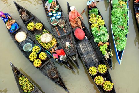
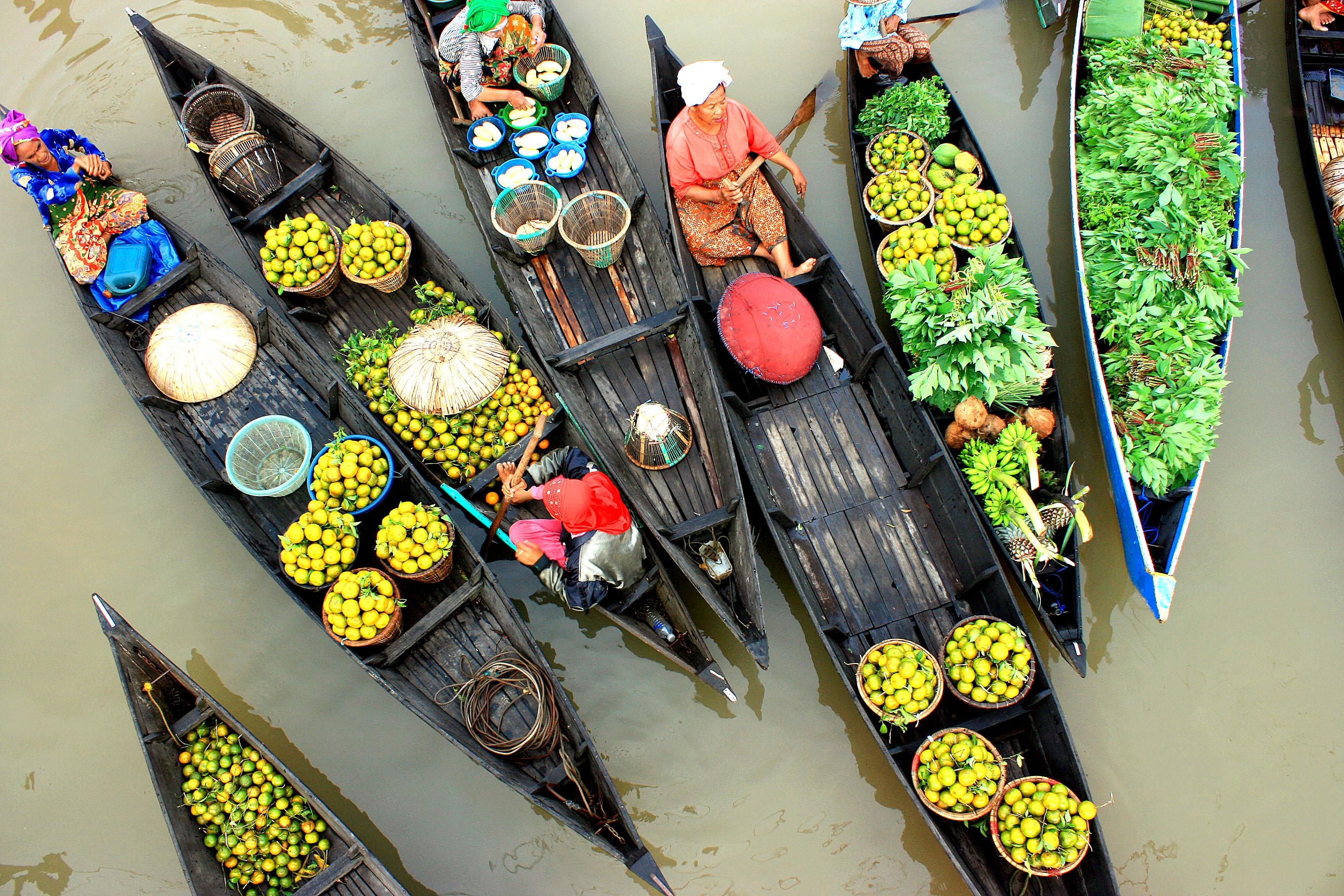
Nunukan crystal water sea

***

Official Name : Kalimantan Utara ( abbreviation : Kaltara)

Origin of Name : North Borneo is long associated with northern part of Borneo, which historically was British occupied areas of Sarawak, Sabah, Labuan (of Malaysia) & tiny Brunei Darussalam sultanate. But, another ‘North Borneo’ is now created. What used to be northern parts of ‘East Kalimantan’ province is eventually made up a brand new province, the 34th province of the Republic of Indonesia: KALIMANTAN UTARA (North Kalimantan) or ‘Kaltara’ for short.

History :  The coastal region was dominated by Berau Kingdom before finally splitted off into Bulungan and Tidung Kingdom.  Bulungan is vazal of Brunei Kingdom, whilst Tidung has inter-marriage relationship with Sulu Sultanate that also dominated the upper north. Somehow the Dutch Indies had included them under its teritorry apart from what British Indies did with Sabah.

From 1960s these areas belong to East Kalimantan Province until 2012, after The DPR-RI (Dewan Perwakilan Rakyat Republik Indonesia) or The House of Representative and the government have officially endorsed the establishment of North Kalimantan as the nation’s 34th province on Thursday, 25 October 2012, ceded from the upper north of East Kalimantan Province.

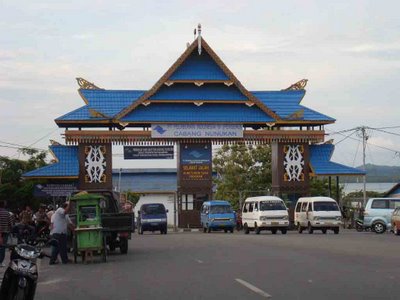
The capital city is not yet decided, but rumor has it, they won’t follow Jakarta or many other provinces which have the capital city as both seat of administration and commercial/industry. Rather, they’d like to follow KL’s pattern on separate those function (which locate administrations offices in Putra Jaya, some few kms away from downtown KL).  So, Nunukan City as well as Tarakan City might as well as the commercial hubs for newly created province, but the capital city is planned to be in Tanjung Selor (a relatively small town yet convenience, located in the heart of Bulungan regency).

The province itself is a long answer to the creation of Indonesian windows in the borderline. A more attention to the welfare and prosperity of our citizens that live along the borders with other country.  With the endorsement on Thursday, Indonesia has 529 autonomous regions, comprising 34 provinces, 402 regencies and 93 municipalities The news from The Jakarta Post

Founded :  20 Oktober 2012

Legality : UU No.20 / 2012

Location : Northern part of  East Kalimantan province, borders with Sabah ( Tawau, Nabawan & Sipitang) & Sarawak ( Kapit, Limbang & Miri ) in the north; and East Kalimantan ( West Kutai, Kutai Kartanegara, East Kutai & Berau ) in the south.

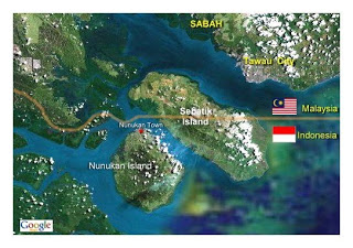
The province also shares Sebatik Island (in Nunukan Regency) with Sabah, Malaysia. Even a house in the island has a livingroom in Indonesia and its kitchen is in Malaysia as it stands just across the borderline.

nunukan_map-google-sat

Capital :  Tanjung Selor (  as of now the city has double functions as the capital city of Bulungan Regency as well as the capital of the brand new created province )

Population :  738,163  / Area : 72.567.49 km2

Province Seal :  / Motto : –not yet–

Administrative divisions : North Kalimantan consists of 4 regencies and 1 city as seen in the map below (yellow) and its previous province East Kalimantan (in white) : KALTARA PETA NORTH KALIMANTAN MAP

1. Tarakan City

2. Bulungan ( Tanjung Selor )

3. Nunukan ( Nunukan City )

4. Malinau ( Malinau City )

5. Tana Tidung ( Tideng Pale )

Zip Code : 77xxx   / Phone Code :    0551 ( Tarakan ); 0552 ( Tg.Selor/Bulungan & Tana Tidung ); 0553 ( Malinau ); 0556 (Nunukan) / Vehicle Plate : KT ( same as East Kalimantan )

University : Universitas Kalimantan Utara (Tarakan) ; Borneo University (Tarakan)

Airport : Biggest airport to reach North Kalimantan is through Juwata Intl. Airport, Tarakan City (TRK) ; The province also has several small airports (lapangan terbang perintis) : Nunukan Airport (NNX) Nunukan town ; Long Bawan/Yuvai Semaring Airport (Krayan, Nunukan) ; Bunyu Airport (BNQ) Pulau Bunyu, Bulungan ; Banaina Airport (NAF) Bulungan ; Tg Harapan Airport (TJS) Tg Selor, Bulungan ; Malinau Airport (MLN) Malinau town ; Long Ampung Airport (LPU) Kayan Selatan, Malinau.

juwata airport

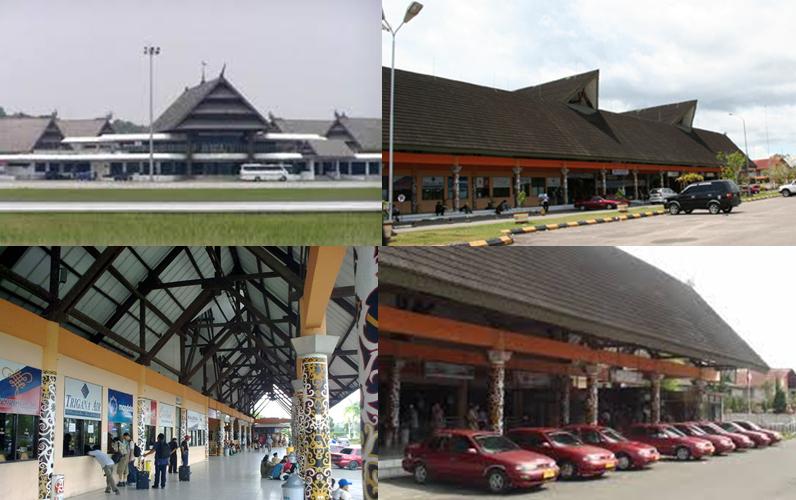
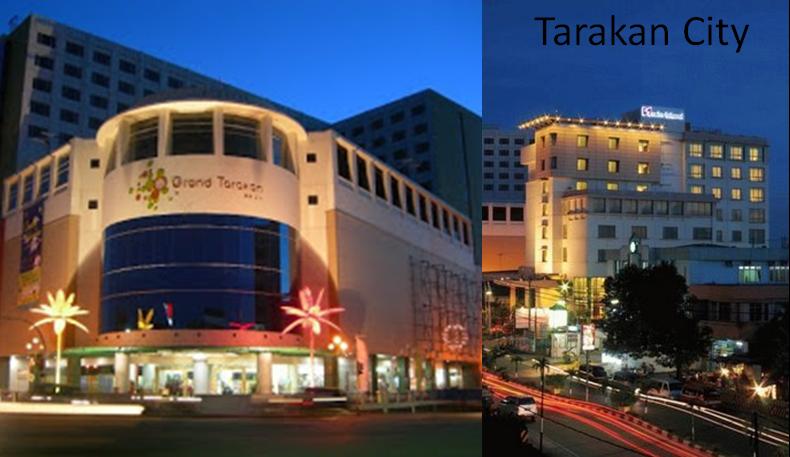
Oil City Tarakan is served by Juwata International Airport

Provincial Flora & Fauna : -na-

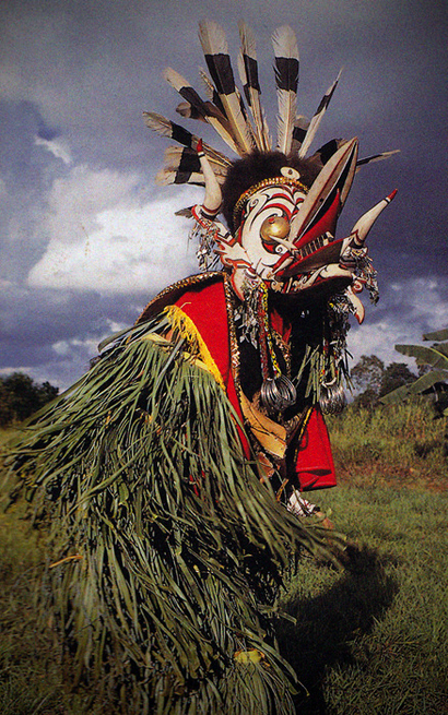
Ethnics of origin: Tidung, Bulungan, Dayak (Kenyah), Berau, Suluk (Tausug), Banjar

Food:

Folksong: Bebilin; Andang Sigurandang ( Tidung ) ; Sulai Mambeng, Dindeng Sayeng (Bulungan)

Dance/Musical art: Tingkilan ensemble ; Jepen

Traditional Clothes:

tidung bride
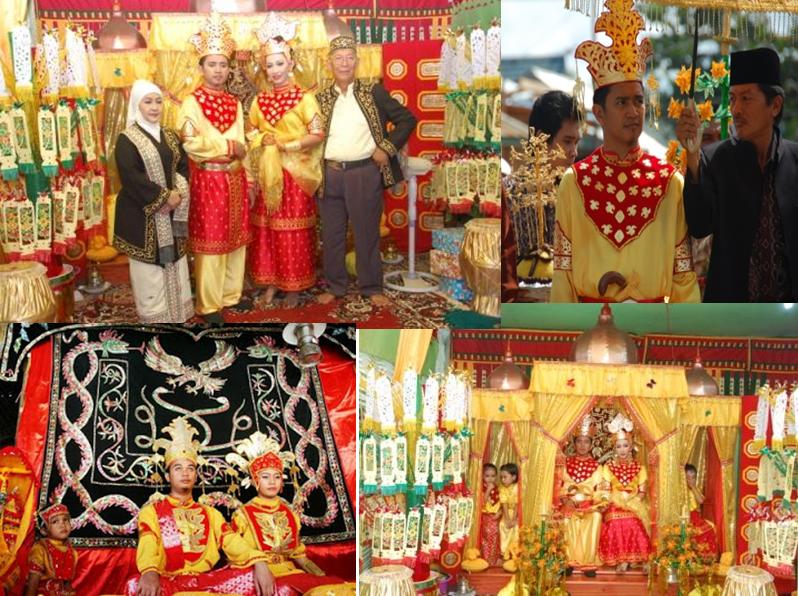
Tidung tribe traditional costume (marriage)

coastal-dayak

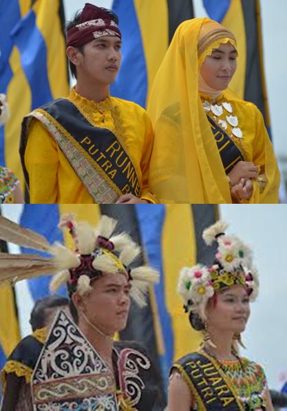
Coastal-Malay Bulungan Traditional outfit (above) – Hinterland Dayak costume (below)

Traditional weapon : Mandau, Sumpit (Dayak);  Keris (Bulungan/Tidung)

Traditional house : Three major cultures that dominate North Kalimantan are of the sultanate (Bulungan), the coastal people (Tidungs) and the hinterland (dayaks). It also reflects province’s traditional houses. Lubung_Intamu.jpeg

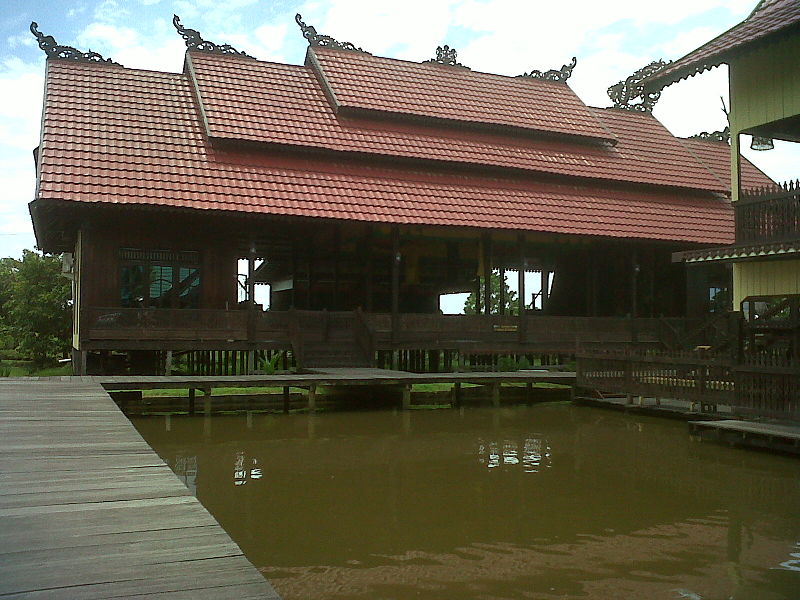
Lubung Intanu of  Tidung tribes’ Rumah Baloy (Tarakan City)

istana sultan bulungan
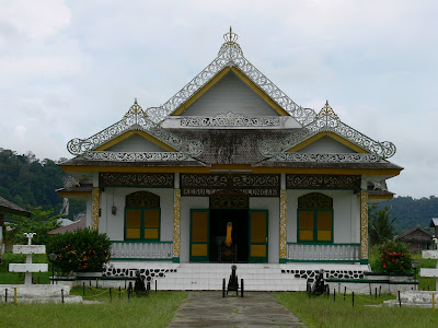
Palace (now a museum) of Sultan Bulungan in Tanjung Palas

setulangDayak traditional house (Setulang, Malinau)

Downtown & Mall : pics

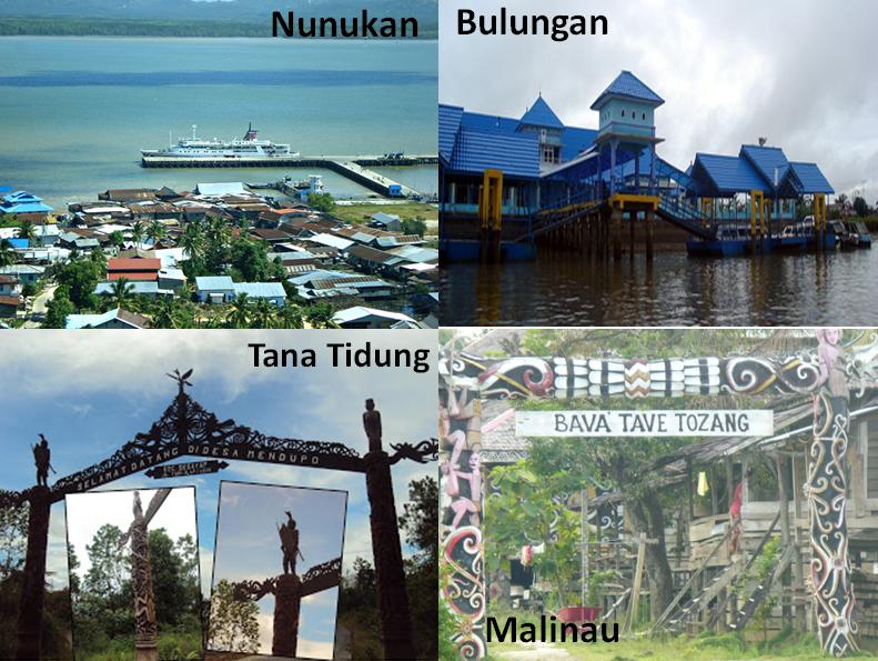
North Kalimantan regencies

trkn cty mall

Port : Tanon Taka Seaport, Nunukan Town.

Nunukan seaport 1

Rivers :  Mountain & Natural :

National Park/Ocean Park : Kayan Mentarang Natl. Park (1,35 million hectare, Bulungan-Nunukan-Malinau)

Bridge & Dam : 

Places of Interest : 

* Nunukan Sea Resorts

*Birau Cultural Festival ( annually – Tarakan City ) showcased all cultural elements of the province (Bulungan, Tidung & Dayak) and other ethnics that live in the province.

*Dayak Festival Malinau

*Historical Tourism, including :  Bulungan Royal Palace (museum) in Tg.Palas, Bulungan. *Adventure Tourism : Dayak village and forest/river trek

Photo Credits: Imanrabinata.blogspot.com ; Sudewi2000.wordpress.com ;

Central Kalimantan Province

Official Name : Kalimantan Tengah (Abbreviation: Kal-Teng) ; Origin of Name : ‘Kalimantan’ is Indonesian (and locals) name of ‘Borneo’. Although many theories exist about its origin, one is from the Indian approach. ‘Kalimantan’ which is often spelled ‘Klemantan’ is derived from Sanskrit : “Kalamanthana” or burning weather island (or island that is very hot temperature). It consists of two words ‘kal[a] : season, period’ and ‘manthan[a] : burning’. But the words “Kalamanthana’ is spelled Kalmantan. And the indigineous people fixed it into Klemantan.

‘Tengah’ means ‘central’, thus ‘Kalimantan Tengah’ refers to ‘Central part of Kalimantan’

History :

Founded : 1956 (prior that was part of Kalimantan Province from 1945-1956, capital in Banjarmasin)

Location : North-Eastern part of Kalimantan. Along Makassar Strait. Bordering Malaysia’s Sabah (Tawau, Nabawan & Sipitang), Malaysia’s Sarawak (Kapit, Limbang & Miri), Central Kalimantan (Murung Raya & Barito Utara), West Kalimantan (Sintang & Kapuas Hulu) & South Kalimantan (Tabalong, Balangan & Kota Baru Daratan).

Capital :

Pop: / Area:

Province Seal :  Motto :

Kalteng Peta Central kalimantan map

Administrative Divisions : 1 city/ 13 Regencies (Municipals):name (its capital) -see the chart with coresponding number-

1. Palangka Raya City (provincial capital)

2. PULANG PISAU (Pulang Pisau City)

3. KAPUAS (Kuala Kapuas)

4. SOUTH BARITO (Buntok)

5. EAST BARITO (Tamiang Layang)

6. NORTH BARITO (Muara Teweh)

7. MURUNG RAYA (Purukcahu)

8. GUNUNG MAS (Kuala Kurun)

9. KATINGAN (Kasongan)

10.EAST KOTAWARINGIN (Sampit)

11.SERUYAN (Kuala Pembuang)

12.WEST KOTAWARINGIN (Pangkalan Bun)

13.LAMANDAU (Nanga Bulik)

14.SUKAMARA (Sukamara City)

ZIP Code :/ Phone Code:  Vehicle Plate :

State University:

Airports:

Province Fauna/Floral:

Ethnics of origin: / Language:

Food: /  Folksong:  Dance-art:

Traditional Clothes:

Traditional weapon : Dayak’s sumpit & Mandau; Coastal Malay’s kris

Traditional house : Typical Dayak’s house is called Rumah Lamin. It’s a long house where many related families live together.

Downtown & Mall :


Rivers, Mountain & Natural :

National Park/Ocean Park :

Bridge & Dam :

Places of Interest :  *Historical Tourism, including : *Religious Tourism, including :  *Adventure Tourism : *Shopping Tourism : (handicrafts as well as many Malaysian & Singaporean products)

Visit : Pics of Provincial Capitol & Landmarks (click here):

Official Map:

West Kalimantan Province

The Great Masjid of The Sultan of Pontianak, where it all began *icon pics : The Enggang Bird in the Borneo’s vast rain forest, is considered holy to Dayak Tribe of Borneo/Kalimantan

Official Name : Kalimantan Barat (Abbreviation: Kalbar ) ; Origin of Name : ‘Kalimantan’ is Indonesian (and locals) name of ‘Borneo’. Although many theories exist about its origin, one is from the Indian approach. ‘Kalimantan’ which is often spelled ‘Klemantan’ is derived from Sanskrit : “Kalamanthana” or burning weather island (or island that is very hot temperature). It consists of two words ‘kal[a] : season, period’ and ‘manthan[a] : burning’. But the words “Kalamanthana’ is spelled Kalmantan. And the indigineous people fixed it into Klemantan.

‘Barat’ means ‘West’, thus ‘Kalimantan Barat’ refers to ‘Western part of Kalimantan’

History :

Founded : 1956 (prior that was part of Kalimantan Province from 1945-1956, capital in Banjarmasin)

Location :

Capital : Pontianak

Pop: / Area:

Province Seal : Motto :

Administrative Divisions : 2 Autonomous Cities (Kota) / 12 Regencies /Municipals (Kabupaten):name (its capital) -see the chart with coresponding number-

1. Pontianak City (also provincial capital)

2. Singkawang City

3. PONTIANAK Regency (Mempawah)

4. LANDAK (Ngabang)

5. BENGKAYANG (Bengkayang City)

6. SAMBAS (Sambas City)

7. KUBU RAYA (Sungai Raya)

8. SANGGAU (Batang Tarang)

9. KAYONG UTARA (Sukadana)

10.KETAPANG (Ketapang City)

11.SEKADAU (Sekadau City)

12.MELAWI (Nangau Pinoh)

13.SINTANG (Sintang City)

14.KAPUAS HULU (Putus Sibau)

ZIP Code :75-77xxx/ Phone Code:  Vehicle Plate : KB (all province)

State University:

Airports:

Province Fauna/Floral:

Ethnics of origin: / Language:

Food: /  Folksong:  Dance-art:


Traditional Clothes:

Traditional weapon : Dayak’s sumpit & Mandau; Coastal Malay’s kris

Traditional house :


Port :

Rivers, Mountain & Natural :

National Park/Ocean Park :

Bridge & Dam :

Places of Interest :  *Historical Tourism, including : *Religious Tourism, including :  *Adventure Tourism : *Shopping Tourism : (handicrafts as well as many Malaysian & Singaporean products)

Visit : Pics of Provincial Capitol & Landmarks (click here):

Official Map:

Pics Credit :

South Kalimantan Province

terapung5

Official Name : Kalimantan Selatan (Abbreviation: Kalsel )

Origin of Name : ‘Kalimantan’ is Indonesian (and locals) name of ‘Borneo’. Although many theories exist about its origin, one is from the Indian approach. ‘Kalimantan’ which is often spelled ‘Klemantan’ is derived from Sanskrit : “Kalamanthana” or burning weather island (or island that is very hot temperature). It consists of two words ‘kal[a] : season, period’ and ‘manthan[a] : burning’. But the words “Kalamanthana’ is spelled Kalmantan. And the indigineous people fixed it into Klemantan.

‘Selatan’ means ‘south’, thus ‘Kalimantan Selatan’ refers to ‘Southern part of Kalimantan’

History :There are three kingdoms in the region: Negara Daha, Negara Dipa & Banjar Sultanate (the latter was a sultanate that dominated majority of Kalimantan). Right after Indonesia’s proclamation of independence (August 17, 1945), the government under Soekarno and Hatta appointed Ir. H. Pangeran Muhammad Noor as the governor of the whole Kalimantan on August 18, 1945. The capital was Banjarmasin. Later on, it was decided to divide the area into several provinces. On December 7, 1956, the province of South Kalimantan was formed out of these areas: Kotawaringin, Dayak Besar (Great Dayak), Daerah Banjar (Banjar Area), and the Federation of Southeast Kalimantan. Later on, Pasir (a part of Southeast Kalimantan Federation) was integrated to the province of East Kalimantan instead. Furthermore, on 23 May 1957, Kotawaringin and Dayak Besar removed themselves from South Kalimantan to form their own province, Central Kalimantan.

Founded : 4 August 1950 (prior that was part of Kalimantan Province from 1945-1950, which its seat is in Banjarmasin, the greatest city in Kalimantan at the time)

Location : Actually it is located in the south-eastern part of Kalimantan. Along Makassar Strait. Bordering Central Kalimantan (Kapuas & All Barito regencies -Utara, Timur & Selatan) & East Kalimantan (Paser), Java Sea and Makassar strait.

Capital : Banjarmasin City (BJM)

Pop: 3,624,132 (16th )/ Area: 38,744 km2 (18th-the smallest in Kalimantan)

Province Seal :  Motto : (Haram Manyarah dari) Wadja Sampai Kaputing (Banjarese). Means: Never Surrender until the last breath

SOUTH KALIMANTAN MAP 2

Administrative Divisions : 2 Cities/ 11 Regencies (Municipals):name (its capital) 

1. BANJARMASIN City (Provincial Capital)

2. BANJARBARU City

3. BANJAR (Martapura)

4. BARITO KUALA (Marabahan)

5.TANAH LAUT (Pelaihari)

6.TANAH BUMBU (Batulicin)

7.TAPIN (Rantau)

8.HULU SUNGA SELATAN / HSS (Kandangan)

9.HULU SUNGAI TENGAH / HST (Barabai)

10.HULU SUNGAI UTARA / HSU (Amuntai)

11.TABALONG (Tanjung)

12.BALANGAN (Paringin)

13.KOTABARU (DARAT & KEPULAUAN) (Kotabaru)

ZIP Code :70-72xxx/ Phone Code: 0511 (Banjarmasin, Banjarbaru, Martapura & Marabahan/Barito Kuala); 0512 (Pelaihari/Tanah Laut); 0517 (Kandangan & Barabai/Hulu Sungai Tengah-Selatan, Rantau/Tapin & Negara); 0518 (Batulicin/Tanah Bumbu & Kotabaru); 0526 (Tanjung/Tabalong); 0527 (Amuntai/Hulu Sungai utara)  Vehicle Plate : DA (all province)

State University: Lambung Mangkurat State University/Unlam (Banjarmasin); Banjarmasin State Polytechnic.

Airports: Syamsudin Noor Airport (Banjarmasin)

Province Fauna/Floral:

Ethnic/Language of Origin: Banjar & Dayak Bukit / Bahasa Banjar (Hulu & Kuala), Bakumpai (Dayak Melayu), Bahasa Dayak (Bukit, Dusun Deyah & Maanyan)

Food: Pais Ikan, Soto Banjar, Wadai, Bingka

Folksong: Ampar-ampar Pisang, Paris Barantai, Saputangan Bapuncu Ampat,  Dance-art: Banjarese Baksa Kembang, Japin, Kuda Gepang, Gamelan & Panting Banjar, Mamanda & Madihin theater, While the internary people belongs to The Dayak Bukit such as : Tari Tandik Balian, Babangsai & Kanjar, Kangkurung music & Balian theater.

Clockwise: Baksa Kambang dancers – Banjar silat ‘Kuntau’ – Princess dance

Clockwise: Mamanda folk theater – Banjar song – Kompang – Panting Ensembles – Topeng Banjar (Mask) Dancers

Traditional Clothes: Banjar traditional outfit (various)

Gajah Bagamuling style – Standard Banjar adat – Nanang/Galuh 

Traditional weapon : Banjarese swift (Serapang, Tiruk & Pangambangan) & two-eyed blade called Duha

Traditional house : Banjar’s Rumah Banjar & Bubungan Tinggi and typical Dayak’s house is called Rumah Balai. It’s a long house where many related families live together.

Downtown & Malls:

downtown Banjarmasin with Barito river flows in it

Port : Bandar Masin Port

Rivers, Mountain & Natural :

National Park/Ocean Park :

Bridge & Dam :

Places of Interest :  *Historical Tourism, including : *Religious Tourism, including :  *Adventure Tourism : *Shopping Tourism :

Visit : Pics of Provincial Capitol & Landmarks (click here):

Official Map:

East Kalimantan Province

Derawan’s crystal water -one of the best Borneo’s beaches *icon pics : Dayak Hudoq’s mask  wore in festival annually

Official Name : Kalimantan Timur (Abbreviation: Kaltim ) ; Origin of Name : ‘Kalimantan’ is Indonesian (and locals) name of ‘Borneo’. Although many theories exist about its origin, one is from the Indian approach. ‘Kalimantan’ which is often spelled ‘Klemantan’ is derived from Sanskrit : “Kalamanthana” or burning weather island (or island that is very hot temperature). It consists of two words ‘kal[a] : season, period’ and ‘manthan[a] : burning’. But the words “Kalamanthana’ is spelled Kalmantan. And the indigineous people fixed it into Klemantan.

‘Timur’ means ‘east’, thus ‘Kalimantan Timur’ refers to ‘Eastern part of Kalimantan’

History :

Founded : 1956 (prior that was part of Kalimantan Province from 1945-1956, capital in Banjarmasin)

Location : North-Eastern part of Kalimantan. Along Makassar Strait. Bordering Malaysia’s Sarawak (Kapit), Central Kalimantan (Murung Raya & Barito Utara), West Kalimantan (Sintang & Kapuas Hulu) & South Kalimantan (Tabalong, Balangan & Kota Baru Daratan).

Capital : Samarinda City (SMR)

Pop: 3,210,407 (19th)/ Area: 204,543 km2 (11% of Indonesia. 2nd rank -only Papua is larger)

Province Seal : Green dominate the seal, represents East Kalimantan’s vast tropical forest. Motto : Ruhui Rahayu (Banjarese). Means: Perfect harmony in the blessing from God


East Kalimantan Map prior its split into brand new North Kalimantan

Note :  According to the “Jakarta Post” of 22 July 2004, there is a proposal to create a new province of North Kalimantan (Kalimantan Utara). It would be split from East Kalimantan (Kalimantan Timur) by taking the regencies (kabupaten)/city on the northern part of the province, except Berau (which decline to join), thus it would consist of Bulungan, Malinau and Nunukan, and the city (kotamadya) of Tarakan. Since that date, a new regency (Tana Tidung Regency) has been created in 2007 out of part of Bulungan Regency, so this would also fall within this putative North Kalimantan Province (see the chart regency/city no.9,11,12,13 & 14)

Administrative Divisions  (after the creation of North Kalimantan Province) :

KALTIM PETA EAST KALIMANTAN MAP

3 Cities/ 6 Regencies (Municipals):name (its capital)

1. Balikpapan City

2. Samarinda City (provincial capital)

3. Bontang City

4. Kutai Kertanegara (Tenggarong)

5. Kutai Barat (Sendawar)

6. Paser (Tanah Grogot)

7. Penajam Paser Utara (Penajam)

8. Kutai Timur (Sangatta)

9. Berau (Tanjung Redeb) 

ZIP Code :75-77xxx/ Phone Code: 0541 (Samarinda & Tenggarong/Kutai Kartanegara); 0542 (Balikpapan); 0543 (Tanah Grogot/Paser & Penajam); 0545 (Melak); 0548 (Bontang); 0549 (Sangatta/Kutai Timur); 0551 (Tarakan); 0552 (Tg.Selor/Bulungan); 0553 (Malinau); 0554 (Tg.Redeb/Berau); 0556 (Nunukan)/ Vehicle Plate : KT (all province)

State University: Mulawarman State University/Unmul (Samarinda); Samarinda State Polytechnic & Borneo University (Tarakan)

Mulawarman State University in Samarinda

Airports: Due to its large area, East Kalimantan has 10 airports (ranging from International to small ones): 1. Sepinggan Intl. Airport (Balikpapan) 2. Juwata Intl. Airport (Tarakan) 3. Temindung Airport (Samarinda) 4. Bontang Airport (Bontang) 5. Nunukan Airport (Nunukan) 6. Kalimaru Airport (Tg.Redep, Berau) 7. Tanjung Harapan Airport (Tg.Selor, Bulungan) 8. Datah Dawai Airport (Long Pahangai, West Kutai) 9. Long Ampung Airport (South Kayan, Malinau) 10.Long Bawan/Yuvai Semaring Airport (Krayan, Nunukan)

Sepinggan International Airport – Balikpapan

Province Fauna/Floral:

Ethnics of origin: Coastals Malays (Kutai, Banjar, Berau & Bajau) & Dayaks (Ot-Danum,Benuaq, Apo Kayan, Kahayan, Kenyah, Punan & Murut)/ Language: Bahasa Banjar, Kutai, Berau & Various Dayak Language

Food: Banjar culture has its impact in East kalimantan culinary, other famous snacks from the province including many crackers from fish/  Folksong: Indung-indung (Berau) Dance-art: As of other elements in the province, there are two general groups of culture, first, the internary people belongs to The Dayaks (Kenyah) with dances such as : Tari Perang, Gong, Anyaman, Tinggang Moru & Hudoq as well as dayak’s carving which is very special.

And coastal Malays (Kutai,Banjar, Paser, Bulungan, Tidung etc) with dances such as: Jepin (Kalimantan’s zapin), Rudaq etc as well as many traditional woven sarongs like famous sarong samarinda.

Traditional Clothes: Dayak outfit & Kutai’s baju adat

Traditional weapon : Dayak’s sumpit & Mandau; Coastal Malay’s kris

Traditional house : Typical Dayak’s house is called Rumah Lamin. It’s a long house where many related families live together.

While coastal Malays lives in a typical rooted house or Rumah Panggung, since usually they live along big rivers or coastal areas.

Downtown & Mall :

Balcony City Mall with oceanview – Balikpapan

View of downtown Samarinda, the capital city

Rivers, Mountain & Natural : Sungai Mahakam (920 km), Sungai Berau, Sungai Kayan. Mount

National Park/Ocean Park : Kayan Mentarang Natl. Park (1,35 million hectare, Bulungan-Nunukan-Malinau); Kutai Natl.Park (2,000 km2. East Kutai-Bontang); Berau Ocean Park

Bridge & Dam : Jembatan Mahakam/Mahkota 1 (Samarinda Kota-Samarinda Seberang); Jembatan Kutai Kartanegara (Tenggarong); Jembatan Mahkota 2 (Samarinda), Jembatan Mahakam Hulu (Samarinda)

Places of Interest :  *Historical Tourism, including : *Religious Tourism, including :  *Adventure Tourism : *Shopping Tourism : (handicrafts as well as many Malaysian & Singaporean products)

Visit : Pics of Provincial Capitol & Landmarks (click here):

Official Map:

Borneo (Kalimantan) Provinces

Wiki says:

In English, the term Kalimantan refers to the Indonesian portion of the island of Borneo, in Indonesian, the term “Kalimantan” refers to the whole island of Borneo.  Borneo (IndonesianKalimantan) is the third largest island in the world and is located north of JavaIndonesia, at the geographic centre of Maritime Southeast Asia.

The island is divided among three countries: BruneiIndonesia and Malaysia. Approximately 73% of the island is Indonesian territory. The Malaysian states of Sabah and Sarawak in the north occupy about 26% of the island. The sovereign state of Brunei, located on the north coast, comprises about 1% of Borneo’s land area.

The Indonesian territory makes up 69.5% (13,772,543 at the 2010 Census of Indonesia) by island’s population. The non-Indonesian parts of Borneo are of Brunei(400,000) and East Malaysia (5,625,000), the latter comprising the states of Sabah andSarawak. The region within Indonesia is also known as Indonesian Borneo.

Kalimantan’s total area is 544,150 square kilometres (210,097 sq mi).

The Indians named Borneo Suvarnabhumi(the land of gold) and also Karpuradvipa (Camphor Island). The Javanese named Borneo Puradvipa, or Diamond Island. Archaeologicalfindings in the Sarawak river delta reveal that the area was once a thriving trading centre between India and China from the 500’s until about 1300 AD.

Administrative divisions:

Indonesian part of Borneo makes up of 4 provinces and subdivised into 44 regencies and 9 cities.

1. West Kalimantan / Kalimantan Barat (capital : Pontianak)

2. Central Kalimantan / Kalimantan Tengah (capital : Palangka Raya)

3. East Kalimantan /  Kalimantan Timur (capital : Samarinda)

4. South Kalimantan / Kalimantan Selatan (capital : Banjarmasin)

Provinces’ seals: